Kanchenjunga Base Camp Trek – 19 days

  • Overview
  • Itinerary
  • Trip Facts
  • Gallery
  • Videos
  • Useful Info

At a glance

Trekking: Kanchenjunga trekking
Grade: Moderate to exhausting
Best season: March, April, May, September, October, November
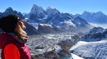
Trekking Significance: Mt. Kanchenjunga  (8586m) Himalayan range, Kanchenjunga conservation area, Sherpa village and their unique culture.

Description

 Kangchenjunga  Base Camp Trek is geographically and culturally superb. Fly from Kathmandu to Biratnagar in the lowlands and up to Suketar. The trail drops, through terraced farmlands and forests to the village of Mitlung on the Tamor River and then follows the river to the picturesque cluster-village of Chirwa. 

Sekathum is a Tibetan village at the confluence of the Tamor and Ghunsa Rivers. The trail branches up the Ghunsa Khola, through oak, rhododendron and bamboo forests. Good views appear from high ground. Amjilosa, with its Cardamom fields, is a wealthy village. A short upward day through forest and scattered pastures leads to Gyabla.

The Kachenjunga base camp trekking trail to Ghunsa passes through larch forests as the valley widens. This is the largest village in the region. Steep forested slopes form the impressive valley sides with snow peaks above. There is a hydro electric plant. On the rest day, visit the Gompa or climb high for aerial views of the village.

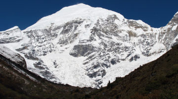
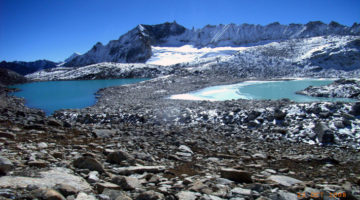
The Kambachenjunga trek Nepal climbs through alpine forests, changing to scrub vegetation as the altitude rises. Cross scree slopes opposite the terminal moraine of the Jannu Glacier beneath the impressive peak before Kambachen. The landscape becomes increasingly desolate in a valley forged by glacial ice. Ice laden peaks tower overhead. The last kharka at Lhonak is set above the Kangchenjunga Glacier, opposite the spectacular Wedge Peak.

From here it is a two hour walk above the glacier to the view point at Pang Pema. Here the glacier makes a sharp turn to the south and rises to reveal the awesome bulk of Kangchenjunga; the crowning glory in a vast and spectacular setting.

The easier return route follows the up-path offering different perspectives and time to consolidate its grandeur. We offer both tea house and camping trekking to Kangchenjunga trek. Our trekking package covers transport, porters, meals, sturdy tent accommodation, and safe drinking water. March to May and September to November are the best months to your Kanchenjunga trekking. 

Outline Itinerary

1 Day 01: Kathmandu – Biratnagar (72m/236ft), 35min flight

The journey begins with an internal flight eastwards to Biratnagar, on the edge of the Indian plains, where we check into our hotel and have a free afternoon. 

2 Day 02: Biratnagar – Suketar – Mitlung (850m/2,790 ft), 15min flight, 5-6 hrs trek

After breakfast and an early flight, we meet our porters at Suketar and then trek down to the village of Asahangpati and on to the Tamor Khola. This major river, and its tributaries, carries the waters off all the mountains to the north to the Ganges. Most villages are situated on high gentle slopes above steep sided valleys where agriculture is possible. We follow it upstream through bird filled forest, to the Chhetri village of Mitlung. Overnight at Mitlung.

3 Day 03: Mitlung - Chirwa (1,190m/3,905ft), 6-7 hrs

Today’s trail passes through dense patches of sub-tropical rainforest and follows the valley, from village to tributary crossings and up again. The region is home to ethnic Kirantis, now known as Limbus, who are chiefly involved in traditional agriculture. Beyond Sinwa, the valley narrows and the trail picks its way over landslides to Tawa. There are many bee hives in this region. Chirwa is a delightful cluster-village set amongst boulders: the campsite is next to a stream beyond the village. Overnight at Chirwa.

4 Day 04: Chirwa - Sekathum (1,640m/5,390ft), 5-6 hrs

Now the valley broadens and the landscape changes subtly. Cross the Sisuwa Khola and continue to Tapethok; the entrance and checkpoint to the Kangchenjunga Conservation Area. Wealthy cardamom farms surround the village. Follow the trail to a bridge over the Tamewa Khola and Tamewa and continue to Hellok. (Between these villages, a bridge leads west to the hilltop village of Lelep: headquarters of the KCA project.)  Beyond Hellok, a suspension bridge crosses the Simbuwa Khola: the river that rises from the Yalung Glacier on Kangchenjunga’s south face. The next bridge crosses the Ghunsa Khola that rises from Kangchenjunga’s north face glacier. This is at its confluence with the Tamur Khola just below the village of Sekathum. The first views of Khumbakarna (Jannu) may be seen. Overnight at Sekathum. 

5 Day 05: Sekathum - Amjilosa (2,490m/8,168ft), 5-6hrs.

After breakfast, we follow the trail along the north bank of the Ghunsa Khola which is set in a steep sided and narrow valley. It passes through oak and rhododendron forest with bamboo undergrowth as well as small Sherpa settlements, mainly tending yaks: there is still evidence of extensive forest burning for slash-and-burn agriculture. After lunch, there is a steep climb up to the small and friendly Tibetan settlement of Amjilosa, set on a small level kharka with great views back down the valley. Overnight at Amjilosa.  

6 Day 06: Amjilosa - Gyabla (2,730m/8,955ft), 4-5hrs.

This is a fairly short day. The trail leads up to a flat ridge and then meanders through forests of bamboo, rhododendron, birch and brown oaks. It passes waterfalls and a few scattered summer pastures. Eventually it reaches a large set of rapids, after which a stiff climb leads up to the Sherpa village of Gyabla. The slopes around the village have been denuded for fields, but the forest remains pristine on the opposite side of the valley. Overnight at Gyabla.

7 Day 07: Gyabla - Ghunsa (3,430m/11,250ft), 5-6hrs

Today’s trail passes through hemlock and bamboo forest as it drops steeply into a ravine before levelling out. The forest gradually changes to alpine Himalayan fir and rhododendron as the path rises towards the large summer yak pastures and potato fields around the village of Phale (3,140m/10,302ft). There is a wooden Gompa with several statues and old thangkas, brought originally from Tibet.

Beyond Phale, the valley widens and the trail improves as it passes through larch forests and cultivated fields. It then dips down to cross the Ghunsa Khola and enter Ghunsa. This is the largest village in the region and is now occupied throughout the year: swelling in numbers as yaks and goats are brought up (and beyond) to pasture during the summer months. 

8 Day 08: Ghunsa: Rest and acclimatisation day.

Ghunsa is an attractive Tibetan village with homesteads spaced in wood-enclosed fields. Steep forested slopes and almost sheer rock faces form the valley sides with snow-clad peaks towering 1,000m above. 

Visit the monastery (belonging to the Khampa Dzong monasteries of Tibet) on the edge of the village. Look for locally made Tibetan carpets. Consider a day hike up the Yamatari Khola, along the Lapsang La trail, to a lake at the terminal moraine of the Yamatari glacier. Alternately follow the trail along the pipe line of the hydro electric plant towards the Tamo La: on the trail to Kangchenjunga’s south base camp. Bharal may be seen grazing above the village.

9 Day 09: Ghunsa - Kambachen (4 150m/13,615ft), 5-6 hrs.

The trail leads north of Ghunsa through glorious larch and juniper forests on the east bank of the Ghunsa Khola. After crossing a sandy, boulder-strewn floodplain it crosses the river over a rickety, wood and stone bridge before climbing above the west bank to Rambuk Kharka (3,720m/12,205ft). The hillsides become increasingly barren as the trail rises past a high waterfall and rock falls along a narrow trail. Further on it crosses a large, sandy landslide before climbing more steeply while passing the impressive snout of the Khumbakarna (Jannu) Glacier on the opposite side of the valley. It then drops briefly into Kambachen. From here there are great views of several peaks including Jannu (7,710m/25,295ft). Lammergeyers, eagles, kites, falcons and choughs are commonly seen. Overnight at Kambachen.

10 Day 10: Kambachen – Lhonak (4,790m/15,900ft), 4-5 hrs

The landscape becomes increasingly desolate; forged over aeons by glacial ice. The path is not strenuous but for a time negotiates the stony river bed before reaching summer-pastoral huts at Ramtang (4,370m/14,338ft). Beyond is the snout of the Kangchenjunga Glacier which has been joined by the Ramtang Glacier. Higher up, the stony path climbs over the moraine and drops to the riverbed of the Ghunsa Khola as it leaves the Lhonak Glacier to the north. Ford the river or cross on a low unstable bridge to the summer grazing kharkas at Lhonak, situated well above the main glacier. There are three small buildings and some old stone walls amongst boulders that can assist with tent-shelter from the icy winds.  Ice peaks rise in all directions with the 1½km ridge of Chang Himal (Wedge Peak) as centre piece. Tent Peak is prominent on the eastern horizon at the end of the visible glacier. Overnight at Lhonak.

11 Day 11: Lhonak – Pang Pema Base Camp (5,160m/16,923ft), 2-3 hrs

From Lhonak the Kangchenjunga Glacier flows eastwards for several kilometres before turning south to rise to its extensive head on the northern slopes of Kangchenjunga. The path follows the lip of the glacier over short grasses or rocky tracks that undulate with the terrain. Pang Pema lies opposite the head of the glacier and from here offers the first full view of the vast north face of the mountain. Overnight at Pang Pema.

12 Day 12: Pang Pema Base Camp, rest and exploration day.

The views from Pang Pema must rank amongst the most spectacular in the world. From Kangchenjunga, an unbroken wall of peaks, nowhere less than 6,100m/20,000ft forms the border with Sikkim and to the north, Tibet. Beyond the campsite the West Langpo Glacier flows into the Kangchenjunga Glacier. A difficult route north leads over the Jonsang La into Tibet. Climb the lower slopes of Drohma Ri (5,500m/18,045ft) behind the camp for better views of the mountain – at sunrise. Walk along the Langpo moraine to Corner Camp for better views of Pyramid Peak, et al. Overnight at Pang Pema. 

13 Day 13: Pangpema – Kambachen (4,150m/13,650ft), 5-6 hrs

The return journey from Pang Pema to Lhonak will be fairly slow, but beyond that the route is almost all downhill and thus Kambachen can easily be reached in a day. There are great views to enjoy. Overnight at Kambachen.

14 Day 14: Kambachen – Ghunsa – Phale (3,140m/10,302ft), 5-6 hrs

Retrace the path down to Ghunsa, for lunch. Look out for pheasants in the forest. Cross the river below the village and continue downstream beside the Ghunsa Khola, through forest and farmland, to the Tibetan summer grazing village of Phale. Visit the wooden gompa. Overnight at Phale. 

15 Day 15: Phale – Amjilosa (2,140m/7,100ft), 5-6 hrs

The trail, through forests of rhododendron, conifer, birch and oak, continues down the valley, dropping to cross numerous tributaries to the last of the Tibetan villages at Gyabla. It then undulates on down to Amjilosa. Overnight at Amjilosa. 

16 Day 16: Amjilosa – Chirwa (1,190m/3,900 ft), 5-6 hrs

After the waterfall beyond the village, the path begins to descend fairly steeply to Sekathum: at the confluence of the Ghunsa and Tamur Kholas. The path then follows the western bank of the Tamur Khola and soon crosses the suspension bridge over the Simbuwa Khola that flows in from the Yarlung Glacier.  An afternoon's walk leads to the riverside campsite a ¼hrs walk before the cluster-village of Chirwa. Overnight at Chirwa.   

17 Day 17: Chirwa – Linkhim (1,520m/4,985ft), 5-6 hrs

From Chirwa, leave the river trail and follow the trail that climbs above the east bank of the Tamor Khola to the hamlet at Thiwa (an exit point from the KCA). It then climbs high above the houses of Tawa, over a ridge before dropping into a side canyon to cross the Tawa Khola before climbing back to the ridge. It then passes above the hamlet of Malbanse before reaching Linkhim. Overnight at Linkhim. 

18 Day 18: Linkhim – Suketar (2,700m/8,856ft.), 5-6 hrs

From Linkhim, the trail winds in and out of side canyons to the Limbu village to Phurumbu and a ridge overlooking a vast landslide before Jogidanda. A final 3-4 hrs climb, through the Sherpa villages of Bung Kulung and Bhote Gaon leads to the airstrip at Suketar. Celebrate with a farewell dinner before saying goodbye to your trekking crew. Overnight at Suketar. 

19 Day 19: Suketar - Biratnagar- Kathmandu (1,300m/4,264ft), 30min and 35min flights

After breakfast, board an early morning flight to Biratnagar and later an onward flight to Kathmandu from where you will be driven to your hotel. Afternoon free. 

Note: B = Breakfast, B.B = Bed & Breakfast, B.L.D = Bed, Breakfast, Lunch & Dinner

If the above itinerary does not meet your needs, we can design individualized travel plans based on your preferences.

Trip Facts

Videos

    Video Not Found

Useful Info

Content Not Found
phone
  • Call us on
  • +977-9842958358

Trip Notes

Download the detailed trip notes for everything you could possibly want to know about this trip, including detailed itinerary and full kit list.

View trip Notes

Customize Trip

We understand that your preferences and interests may be different. Tell us about your requirements and what you expect from the tour, and we will help you design a package with comfortable itinerary to best meet your needs. Please send enquiry to organize your own trip. We will feel happy to help you.

Send Enquiry
book

Download brochure

We are here to provide you the online brochure. Click here to download.

Need Inspiration for Your Next Tour?

Translate »